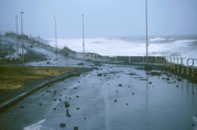
| Wind power: the winds reach their maximum speed and strength at the periphery of the eye. When a cyclone makes landfall the winds are modified: the roughness changes and in the case of the presence of a mountainous terrain (as for La Réunion Island) the turbulent character of the winds is highly increased. This results into a weakening of the average wind whereas the peak gusts are enhanced compared to the situation at sea. The orography also generates local effects, either blocking the winds or accelerating them (by Venturi effect along the coasts parallel to the flow or along the edges of exposed cliffs).winds reach their maximal force in the eyewall (at the periphery of the eye). The relief of La Réunion leads to local strengthening of the wind. | |
|
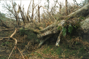
Rainfall: whatever being generated by a tropical storm or a mature cyclone the rains brought about by a tropical system are frequently torrential which cause floods, rock falls and landslides. The presence of mountain ranges or a strong orography increases the rainfall amounts, the main reason why La Réunion holds all the world records of rainfall for period ranging from 12 hours to 15 daysthe torrential rainfall associated to the system leads to floods, rock slides or landslides. |
| The sea: the rise of the average sea level average induced by the passage of a cyclone combines with the huge waves of the cyclone swell to undermine the shore or flood the coastal plains. Bathymetry plays a major role in this process: shallow waters will favour an amplification of the storm surge phenomenon and also the run-up and inland propagation of the breaking waves while a marine profile associated with rapidly increasing depth (such as the topography of La Réunion) will limit the effect of this phenomenon. |
|
Tropical cyclones constitute one the most powerful atmospheric phenomena. The titanic energy it involves equals that of several Hiroshima-type atomic bombs per second! It functions like a thermal machine, a heat pump with the source of cold air coming from the high troposphere, and the source of warm air coming from the ocean where the cyclone draws the thermal energy which it then transforms into a whirling movement and into rain-bearing clouds. The tropical cyclones act like a safety valve which enable the excess of energy being accumulated in the overheated tropical oceans to evacuate into the atmosphere (hence primarily during the summer season).
However, this large scale regulating role of the tropical cyclones of the atmospheric machine is overshadowed by the often catastrophic consequences of these meteorological phenomena which constitute one of the most devastating natural hazards. Whether on the high seas or all the more so near land, the colossal release of energy into motion (the wind) or into latent heat (rainfall) that takes place within the cyclone is accompanied by various phenomena which may all have cataclysmic consequences locally.
The major hazards of a cyclone are thus connected with the action of the wind, of the rain, and of the sea (cyclone swell and storm surge).
The strength of the wind and the related brutal changes in direction and intensity which may take place cause considerable damage.
The energy produced by the wind is proportional to the square of its speed. Which means that a 200 km/h wind is not twice, but 4 times as powerful as a 100 km/h wind. Then the damage increases very rapidly with the speed, not in a linear, but in an exponential way. For reference purposes, the wind pressure exerted on a flat surface which is perpendicular to it is about 50 kg/m² for a 100 km/h wind, 100 kg/m² for a 140 km/h wind, 200 kg/m² for a 200 km/h wind, and 300 kg/m² for a 240 km/h wind (according to the formula P = 1/2 ρv²/9.81, which is expressed in kg/m², and where, the density of dry air is a constant with a value of 1.293 kg/m³ and v is the wind speed in m/s).
Besides, the wind does not blow regularly, but in a turbulent way. The gusts (instantaneous measure of the wind, for a 1 to 3 seconds duration) sometimes exceed the value of the average wind by more than 50%. Inside a tropical low-pressure system, it is estimated that the peak gusts over the sea reach 1.41 times the maximum value of the 10 minutes average wind.
Because of the tightening of the pressure gradient as getting closer from the storm's centre, the wind increases in an almost exponential way to reach its maximum speed beneath the cyclone eyewall. Within the eye, winds are weak. The duration of the lull depends on the size of the eye (average diameter is 30 to 80 km, with extreme values from 13 km, measured by radar for TC Tracy in 1974 in northern Australia, to 185 km for Kerry measured by air reconnaissance northeast of Australia in 1979) and on the cyclone's motion (from zero to 30/35 km/h in the tropical domain, but which may exceed 40 to 50 km/h during eastward evacuation into higher latitudes). The lull may last several hours (two hours for an eye of an average diameter of 50 km moving at 25 km/h for example), and then, suddenly, the wind resume at maximum speed, but in the opposite direction. The induced distortion is a major source of damage.
| The strongest winds blow in the eyewall. They decrease very rapidly as one moves away from the inner core of the cyclone (more or less rapidly according to the cyclone's size), so that the really devastating winds rarely spread beyond about a hundred kilometres from the centre. However, violent winds may also blow in some particularly active outer spiral cloud bands. |
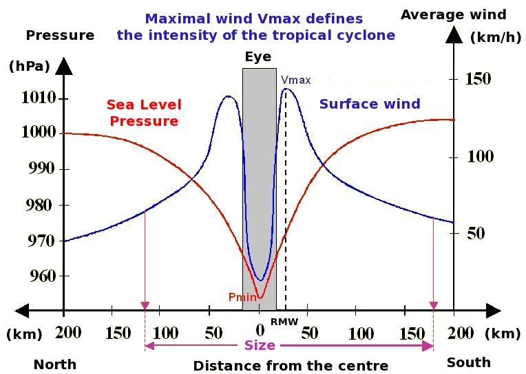
Wind and pressure profiles within |
A tropical disturbance generates torrential rains which can often have more devastating consequences than those of the wind (floods, landslides, mudslides, rock falls, overflowing torrents or ravines).
Unlike the wind, the intensity of rainfall is not linked with the intensity of the disturbance. Relatively weak tropical low-pressure systems (simple tropical depressions, poorly organized areas of disturbed weather) may yield heavier rains than mature cyclones. Besides, even for similar intensity, rainfall varies a lot from one cyclone to another. Popular language reflects these disparities by making a distinction between "wind" and "rain" cyclones.
The amounts of rainfall are related to the speed of movement of the meteor which generates them (the more slowly it moves, the longer the rain might last), and also to the size and to the cloud structure of the phenomenon, often asymmetrical. Heavy rain and stormy showers may occur in the peripheral cloud bands up to 1000 km from the centre for the widest phenomena. If the central part (the eyewall region) falls apart rather rapidly when reaching a continent, with a resulting decrease in the intensity of the winds and of the heaviest rains, these outer spiral cloud bands resist the transition more easily and are often responsible for intense and lasting rains inland, or even tornadoes.
Precipitations are measured in millimetres (mm). One recorded millimetre corresponds to 1 litre of water falling on 1 square metre. For example, 100 mm of rain roughly correspond to 500,000 litres falling on a football ground! In La Réunion, where amounts of rainfall over 100 mm (because of the relief, see thereafter) are quite common, one can imagine how important the amount of water and the potential damage can be. When a storm affects the island, often more than a billion tons of water pours down on to the island...
On the high seas, if the average intensity of rainfall in the more active clouds of the system (within a radius of 100 to 200 km around the eye) is about 80 to 100 mm per day, it is not uncommon to observe values from 300 to 400 mm in 24 hours locally.
When a system reaches a continent (or an increased surface roughness) a strong convergence takes place in the windward area, intensifying the convective vertical movements and accelerating the development of rainfall on the coastal regions. Besides, the presence of high mountains strengthens the uplifts all the more and then the rainfall (orographic effect: the air is forced to ascend along the mountain slopes. As it rises, it cools down and can contain less humidity in vapour form. Then the excessive humidity condenses and turns into clouds and rain). In La Réunion Island, with its two high summits with steep slopes culminating to 2630 m and 3070 m, this fact takes on considerable importance. Owing to the extraordinary quantity of rains it receives, the island holds all the world records for rainfall measured for periods going from 12 hours to 15 days. These records are all due to storms or cyclones (see table below).
In addition, the damage caused by the rains also depends on the pre-existing hydrological and geological context: floods and damage will be more extensive if the ground is already waterlogged, while the first rains falling on dry ground will not favour landslides, but surface erosion will be more important. A young island like La Réunion with intense erosion and high mountains, accumulates the characteristics which make it very sensitive to rains (but it is also accustomed to them and if the high mountains amplify rainfall, on the other hand it makes it easier for water to evacuate quickly). In addition to the direct destructions during the passage of a cyclone, damage induced by the ground rendered unstable by the precipitations may occur several days or even several weeks after a period of heavy rain. Such was the case of the landslide which took place on the main coastal road on 24 March 2006, i.e. 15 days after the passage of tropical storm Diwa. This geological hazard due to heavy rain is much more uncertain and unpredictable.
| Duration | Sites | Date (dd/mm/yy) | Height (mm) |
|---|---|---|---|
| 1 mn | Unionville Md (152 m) USA | 04/07/1956 | 31.2 |
| 15 mn | Plum Point Jamaica | 12/05/1916 | 198.1 |
| 1 h (42 min.) | Holt (Montana) (263 m) USA | 22/06/1947 | 304.8 |
| 12 h | Foc Foc (2290 m) La Réunion (Denise) | January 1966 | 1144 |
| 24 h | Foc Foc (2290 m) La Réunion (Denise) | January 1966 | 1825 |
| 48 h | Aurère (940 m) La Réunion (Unnamed system) | April 1958 | 2467 |
| 3 days | Commerson (2310 m) La Réunion (Gamède) | February 2007 | 3929 |
| 4 days | Commerson (2310 m) La Réunion (Gamède) | February 2007 | 4869 |
| 5 days | Commerson (2310 m) La Réunion (Gamède) | February 2007 | 4979 |
| 6 days | Commerson (2310 m) La Réunion (Gamède) | February 2007 | 5075 |
| 7 days | Commerson (2310 m) La Réunion (Gamède) | February 2007 | 5400 |
| 8 days | Commerson (2310 m) La Réunion (Gamède) | February 2007 | 5510 |
| 9 days | Commerson (2310 m) La Réunion (Gamède) | February 2007 | 5512 |
| 10 days | Commerson (2310 m) La Réunion (Hyacinthe) | January 1980 | 5678 |
| 15 days | Commerson (2310 m) La Réunion (Hyacinthe) | January 1980 | 6083 |
| 1 month | Cherrapunji Inde (1310 m) | July 1861 | 9300 |
| 1 year | Cherrapunji Inde (1310 m) | August 1860 to July 1861 | 26461 |
| 2 years | Cherrapunji Inde (1310 m) | from 1860 to 1861 | 40768 |
Rainfall world records. All the rainfall records for periods from 12 hours to 15 days are held by La Réunion Island and are related to tropical storms or cyclones. For shorter periods, the records are related to stormy rains; for longer periods they are due to the Indian monsoon.
If cyclone rainfall may have direct or indirect disastrous impact (on infrastructures, for agriculture, or due to sanitary consequences in particular), it must be underlined that it also has a positive effect. The water supply of some tropical islands such as Rodrigues for example, relies almost exclusively on the rains generated by the tropical low-pressure systems: from this point of view, it can be said that for these islands, cyclones are a necessary evil.
In the core of the cyclone, the violent winds generate huge waves by rubbing the surface of the sea. The waves can reach 10 to 20 meters significant height (which corresponds to the average of the third of the highest waves- intuitive visual estimation given by seamen). The highest wave ever lifted by a cyclone and measured from a ship was estimated to be 34 metres high (American ship USS Ramapo) on 7 February 1933 in the North-West Pacific.
The cyclone swell is created when strong winds blow long enough over the same zone. Consequently, the height of the swell depends on the wind speed and on the time during which it has blown. The swell, an undulation of very wide amplitude, generally moves more rapidly than the cyclone itself. It is then often a harbinger sign of an approaching depression and it can reach land long before the weather conditions worsen (that was in fact how people in the past could anticipate the coming of a "gale", as local people call cyclones). It can also make itself felt far from the cyclone, up to 1000 km from the system, without the latter necessarily passing nearby. The damage caused by the swell depends on its height and its period, but also on the coastal profile (a shallow coastal plateau tends to amplify the waves). The most energetic swells are associated with high periods (cyclone winds typically correspond to moderately energetic periods, of the order of 12 to 15s, but the faster the cyclone moves, the more it can potentially lift high-period swells - keeping in mind that the swell spreads at a speed of 1.5 times the period measured in seconds, therefore often at a speed of about 40 km/h).
It may be pointed out that, because of their more widespread fetch (size and duration of the zone of strong wind), the violent storms in temperate regions (in the "roaring" forties or the "howling" fifties in particular), generate waves and swells that may be even higher than those generated by tropical cyclones. In the Southern hemisphere, the swells known as "polar swells", formed by the deep depressions of the Far South, come from the southwest, while the cyclone swells come mostly from the north or the east, at least as far as the Mascareignes Islands and the east coast of Madagascar are concerned.
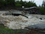
Although far less well-known, the storm surge is the most lethal and devastating phenomenon that comes with cyclones. It is particularly dangerous in the low level coastal regions with a bay and a large and shallow continental plateau where an enormous quantity of water lifted by the cyclone can penetrate the area up to several kilometres inland and drown and destroy everything on the way, generating tidal waves similar to tsunamis from seismic origin (earthquakes), but for which they should not be mistaken.
The storm surge is an anomalous rise of the average sea level associated with the passage of a cyclone. This single rise ("solitary wave") lasts several dozens of minutes (up to one or two hours). It may be from a few centimetres to a few metres high (its very variable magnitude may reach 4 to 8 metres for powerful cyclones and in the areas with a wide continental plateau). It may spread over an area over 10 to several dozens of km wide. The storm surge comes to a climax just in front of the cyclone: in the left forward sector (according to the direction in which the cyclone moves) in the Southern hemisphere, and in the right forward sector in the Northern hemisphere. Just like the swell, the storm surge amplifies as it approaches the coasts. However, on coasts or islands where the sea bed is quickly very deep in the open sea (as in La Réunion or other islands of volcanic origin), the extra rise due to the simple presence of a cyclone (aside from astronomical tide) will be smaller, from 1 to 1.5 metres at the very most.
The storm tide is the sum of the normal astronomical tide and of the "storm wave", also called "surge", which is the rise of the average sea level due to the combined action of the wind and of the pressure fall in the core of the cyclone.
The rise due to the pressure fall, or "inverted barometer effect" can be explained as follows: in the core of the cyclone, the weight of the column of air above the surface is lighter and the sea is "sucked up" so to speak. An easy to remember rule of thumb is that a drop of 1 hPa corresponds to a rise of one centimetre. Therefore, keeping in mind that the average sea-level pressure is about 1013 hPa, and that the central pressure of the most powerful cyclones is about 900 hPa (minimal record measured : 870 hPa for super typhoon Tip), one can come to the conclusion that the sucking up effect due to the pressure fall is around several dozens of centimetres, up to a little more than one metre at the very most.
In fact, most of the storm surge is due to the action of the strongest winds at the periphery of the eye, which mechanically push the water in front of the cyclone. These winds generate a very strong current (called "drift current") by friction on of the ocean's surface. On the high seas, this current is partly compensated, beyond a depth of 50 to 60 metres, by a counter-current in the opposite direction. The amplitude of the storm wave is then relatively small. When the cyclone reaches a continental plateau or comes near land, this counter-current disappears and the surface water accumulates towards the shore (all the more so as the continental plateau is extensive).
Consequently, the amplitude of the storm tide depends on the intensity and of the structure (the size especially) of the tropical cyclone (or the storm, as this phenomenon can also be noticed in temperate zones), but also on other independent factors, such as the configuration of the coast, the topography of the sea bed, the trajectory of the phenomenon, the astronomical tide: a high tide of great amplitude (spring tide), a straight trajectory of the storm, perpendicular to the coast, an estuary, a bay or a delta in which the water will be trapped as in a marine "cul de sac" (such as the bottom of the Gulf of Bengal), shallow sea beds, are so many factors which will considerably increase the rise of the water.
The highest storm tide, acknowledged by the WMO, is 13 metres in May 1899 in a Queensland bay in Australia (Cyclone Mahina, better known as the "Batshurst Bay Hurricane"). Many testimonies at that time confirm this estimation, which might seem questionable. The storm surge which took such a heavy toll among the population (more than 300 000 victims)in 1970 in Bangladesh (whose delta is very vulnerable and very often exposed), was estimated between 4 and 6 metres. More recently, the devastations caused by Hurricane Katrina in 2005 in Mississippi or cyclone Nargis (May 2008, more than 100,000 victims) in Burma are mainly due to storm surges.
All the meteorological records authenticated by the WMO are available at http://wmo.asu.edu