A) Basic definitions
A1) What is a hurricane, typhoon, or tropical cyclone ?
A2) What is a super-typhoon? What is a major hurricane ? What is an intense hurricane ?
A3) What is a tropical disturbance, a tropical depression, or a tropical storm ?
A4) What is a sub-tropical cyclone ?
A5) What is an extratropical cyclone ?
A6) What is storm surge and how is it different from storm tide ?
A7) What is a "CDO" ?
A8) What is a "TUTT"?
A9) What is the "eye" ? How is it formed and maintained ? What is the "eyewall" ?
A10) What is UTC, GMT, Z, or Zulu Time ?
A11) How do I convert from mph to knots (or m/s), or from degrees of latitude to miles (or kilometers) ?
A12) How do tropical cyclones form ?
A13) Why do tropical cyclones require at least 26.5°C ocean temperatures to form ?
Subject A1) What is a hurricane, typhoon, or tropical cyclone ?
Contributed by Chris Landsea
The terms "hurricane", "typhoon" and "tropical cyclone" are regionally specific names for a strong tropical system. A "tropical system" is the generic term for a non-frontal synoptic scale low-pressure system over tropical or sub-tropical waters with organized convection (i.e. thunderstorm activity) and definite cyclonic surface wind circulation (Holland 1993).
Tropical cyclones with maximum average surface winds of less than 17 m/s (34 kt, 39 mph) are called "tropical depressions" (This is not to be confused with the condition mid-latitude people get during a long, cold and grey winter wishing they could be closer to the equator ;-)). Once the tropical cyclone reaches winds of at least 17 m/s (34 kt, 39 mph) they are typically called a "tropical storm" and assigned a name. If winds reach 33 m/s (64 kt, 74 mph)), then they are called:
- "tropical cyclone" (the Southwest Indian Ocean)
- "hurricane" (the North Atlantic Ocean, the Northeast Pacific Ocean east of the dateline, or the South Pacific Ocean east of 160E)
- "typhoon" (the Northwest Pacific Ocean west of the dateline)
- "severe tropical cyclone" (the Southwest Pacific Ocean west of 160E or Southeast Indian Ocean east of 90E)
- "severe cyclonic storm" (the North Indian Ocean).
We can notice that the definition of the "maximum average surface winds" is different according to the organizations. WMO recommends a 10 minutes average surface winds. A lot of the countries use this time step as a standard. However, the "National Hurricane Center" (NHC) and the "Joint Typhoon Warning Center" (JTWC) from USA use a 1 minute average time to calculate the average winds. This difference leads to difficulties when statistics have to be done on numbers of tropical systems all over the world, as a smaller time step increases the number of cases.
(Neumann 1993).
Subject A2) What is a super-typhoon? What is a major hurricane ? What is an intense hurricane ?
Contributed by Stan Goldenberg.
"Super-typhoon" is a term utilized by the U.S. Joint Typhoon Warning Center for typhoons that reach maximum sustained 1-minute surface winds of at least 130 kt (240 km/h).
This is the equivalent of a strong Saffir-Simpson category 4 or category 5 hurricane in the Atlantic basin or a category 5 severe tropical cyclone in the Australian basin, or an intense tropical cyclone in the South West Indian Ocean.
"Major hurricane" is a term utilized by the National Hurricane Center for hurricanes that reach maximum sustained 1-minute surface winds of at least 50 m/s (96 kt). This is the equivalent of category 3, 4 and 5 on the Saffir-Simpson scale.
"Intense hurricane" is an unofficial term, but is often used in the scientific literature. It is the same as "major hurricane".
Subject: A3) What is a tropical disturbance, a tropical depression, or a tropical storm ?
Contributed by Anne-Claire Fontan.
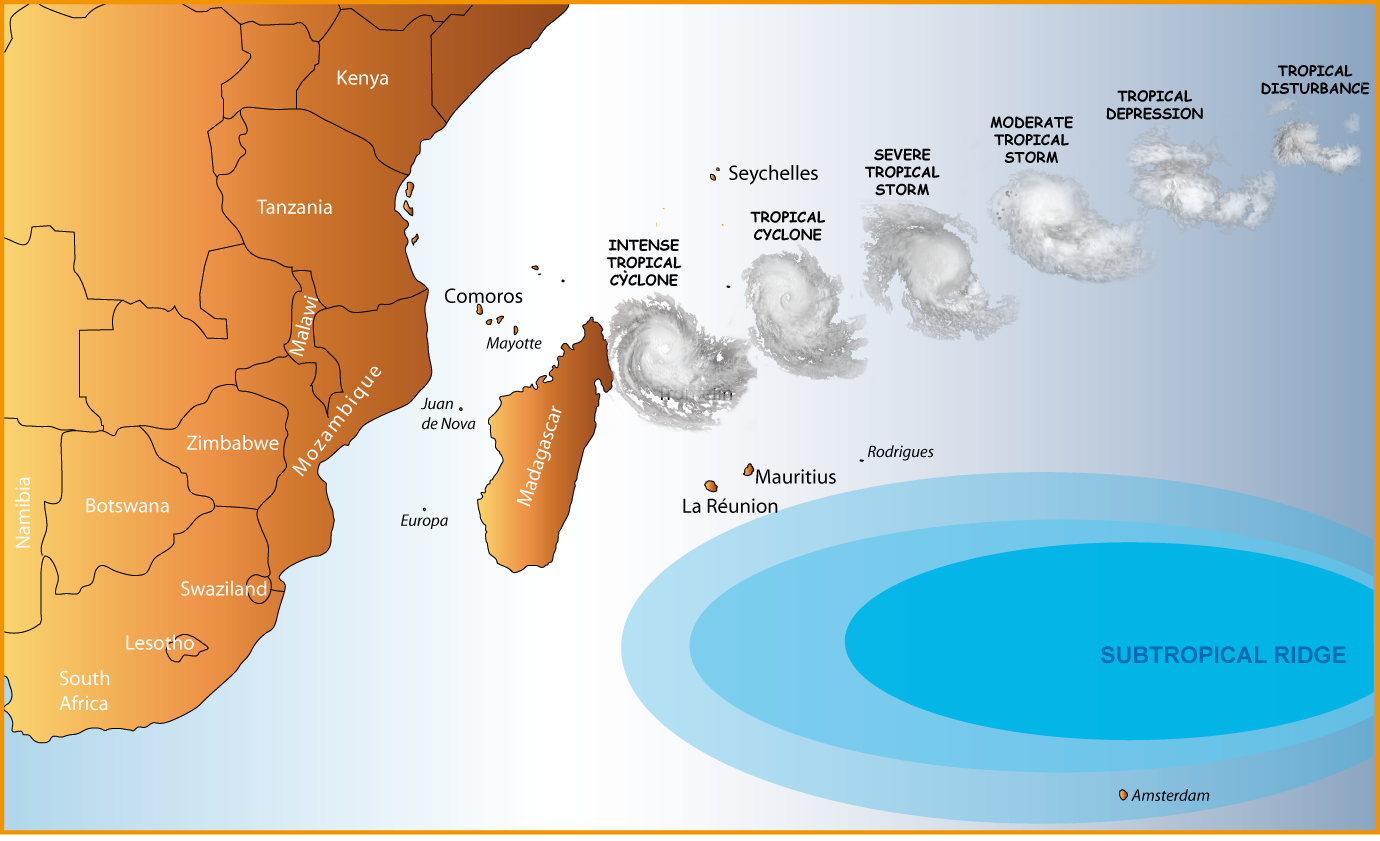
These are terms used to describe the progressive levels of organized disturbed weather in the tropics over the south-west Indian ocean:
Tropical Disturbance
A discrete tropical weather system of apparently organized convection - generally 200 to 600 km (100 to 300 nmi) in diameter - originating in the tropics or subtropics, having a nonfrontal migratory character, and maintaining its identity for 24 hours or more. This cloudy system is associated to a clockwise circulation with maximum average surface wind speed of less than 27 knots (51 km/h].
Tropical Depression
A tropical system in which the maximum average surface wind speed ranges from 28 to 33 knots [51-62 km/h]. Depressions have a closed circulation.
Moderate Tropical Storm
A tropical system in which the maximum average surface wind speed ranges from 34 kt to 47 kt [63-87 km/h]. At this level, systems are usually named.
Severe Tropical Storm
A tropical system in which the maximum average surface wind speed ranges from 48 kt to 63 kt [88-17 km/h]. The convection in tropical storms is usually more concentrated near the center with outer rainfall organizing into distinct bands.
Tropical cyclone
A tropical system in which the maximum average surface wind speed is above 63 kt [118 km/h]. We can then discriminate the intense tropical cyclone (90-115 knots) [166-212 km/h] and the very intense tropical cyclone (winds up to 116 knots [212 km/h]).
The wind speed mentioned here are for those measured or estimated as the 10 minutes average one at 10 meters above the surface. Peak gusts can be on the order of 40% higher.
Subject A4) What is a sub-tropical system ?
Contributed by Chris Landsea, adapted by Anne-Claire Fontan.
A sub-tropical system is a low-pressure system existing in the tropical or subtropical latitudes (anywhere from the equator to about 50°N/S) that has characteristics of both tropical systems and mid-latitude (or extratropical) systems.
Therefore, many of these systems exist in a weak to moderate horizontal temperature gradient region (like mid-latitude cyclones), but also receive much of their energy from convective clouds (like tropical cyclones). Often, these storms have a radius of maximum winds which is farther out (on the order of 100-200 km from the center) than what is observed for purely "tropical" systems. Additionally, the maximum average surface winds for sub-tropical cyclones have not been observed to be stronger than about 50 kts [92 km/h].
Sometimes these subtropical storms transform into true tropical cyclones. This transformation is rather frequent over the Atlantic basin - Hurricane Florence in November 1994 is a recent example – but is much more uncommon over the Southern Indian Ocean (an example could be the system nr 11 in June 2001).
These systems are monitored and RSMC issues forecasts and warnings similar to those for tropical systems. Now they are given names from the tropical cyclone list.
For more information see "Penn State University's write up on the Subtropical Cyclones".
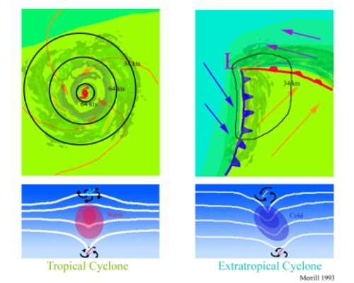
Subject A5) What is an extratropical cyclone ?
Contributed by Stan Glodenberg.
An extra-tropical cyclone is a system that primarily gets its energy from the horizontal temperature contrasts that exist in the atmosphere. Extra-tropical systems (also known as mid-latitude or baroclinic systems) are low pressure systems with associated cold fronts, warm fronts, and occluded fronts.
Tropical systems, in contrast, typically have little to no temperature differences across the storm at the surface and their winds are derived from the release of energy due to cloud/rain formation from the warm moist air of the tropics (Holland 1993, Merrill 1993).
 Figures for the northern hemisphere
The top schematics show horizontal maps of the surface temperature and wind fields associated with a tropical system (left) and an extratropical system (right). Colors indicate temperature (blue 15C=59F, blue green 20C=68F, green 25C=77F). Solid lines indicate surface windspeeds - 34 kt (average on 1mn) = 63 km/h and 64 kt (average on 1minute) = 117 km/h. The bottom schematics show vertical maps of the pressure surfaces and circulation at the surface and tropopause.
Structurally, tropical systems have their strongest winds near the earth's surface , while extra-tropical systems have their strongest winds near the tropopause - about 8 miles (12 km) up.
These differences are due to the tropical system being "warm-core" in the troposphere (below the tropopause) and the extra-tropical system being "warm-core" in the stratosphere (above the tropopause) and "cold-core" in the troposphere. "Warm-core" refers to being relatively warmer than the environment at the same pressure surface ("pressure surfaces" are simply another way to measure height or altitude).
Often, a tropical system will transform into an extra-tropical system as it recurves poleward and to the east. Occasionally, an extra-tropical cyclone will lose its frontal features, develop convection near the center of the storm and transform into a full-fledged tropical cyclone. Such a process is most common in the North Atlantic and Northwest Pacific basins.
The transformation of tropical system into an extra-tropical system (and vice versa) is currently one of the most challenging forecast problems (i.e., Jones et al. 2003).
References:
Jones, S.C., Harr, P.A., Abraham, J., Bosart, L.F., Bowyer, P.J., Evans, J.L., Hanley, D.E., Hanstrum, B.N., Hart, R.E., Lalaurette, F., Sinclair, M.R., Smith, R.K., Thorncroft, C. 2003: The Extratropical Transition of Tropical Cyclones: Forecast Challenges, Current Understanding, and Future Directions. Weather and Forecasting, 18, 1052-1092.
Merrill, R. T., (1993): "Tropical Cyclone Structure" - Chapter 2, Global Guide to Tropical Cyclone Forecasting, WMO/TC-No. 560, Report No. TCP-31, World Meteorological Organization; Geneva, Switzerland.
Subject A6) What is storm surge and how is it different from storm tide ?
Contributed by Neal Dorst.
Storm surge is the onshore rush of sea or lake water caused by the high winds associated with a landfalling cyclone and secondarily by the low pressure of the storm.
Storm tide is the addition of the storm surge and the astronomical tide.
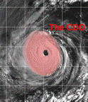
Subject A7) What is a "CDO" ?
Contributed by Chris Landsea.
 NRL-Monterey Imagery
"CDO" is an acronym that stands for "central dense overcast". This is the cirrus cloud shield that results from the thunderstorms in the eyewall of a tropical cyclone and its rainbands. Before the tropical system reaches cyclone strength (33 m/s, 64 kts), typically the CDO is uniformly showing the cold cloud tops of the cirrus with no eye apparent. Once the system reaches the cyclone strength threshold, usually an eye can be seen in either the infrared or visible channels of the satellites. Tropical cyclones that have nearly circular CDO's are indicative of favorable, low vertical shear environments.
Subject A8) What is a "TUTT" ?
Contributed by Chris Landsea.
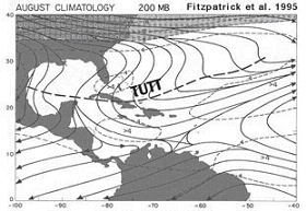 Fitzpatrick et al. (1995)
A "TUTT" is a Tropical Upper Tropospheric Trough. A TUTT low is a TUTT that has completely cut-off. TUTT lows are more commonly known in the Western Hemisphere as an "upper cold low". TUTTs are different than mid-latitude troughs in that they are maintained by subsidence warming near the tropopause which balances radiational cooling. TUTTs are important for tropical cyclone forecasting as they can force large amounts of vertical wind shear over tropical disturbances and tropical cyclones which may inhibit their strengthening. There are also suggestions that TUTTs can assist tropical cyclone genesis and intensification by providing additional forced ascent near the storm center and/or by allowing for an efficient outflow channel in the upper troposphere. For a more detailed discussion on TUTTs see the article by Fitzpatrick et al. (1995).
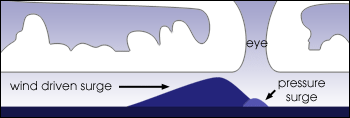
Subject A9) What is the "eye" ? How is it formed and maintained ? What is the "eyewall" ?
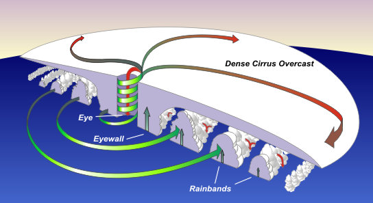 NOAA
NOAA
The "eye" is a roughly circular area of comparatively light winds and fair weather found at the center of a severe tropical cyclone. Although the winds are calm at the axis of rotation, strong winds may extend well into the eye. There is little or no precipitation and sometimes blue sky or stars can be seen. The eye is the region of lowest surface pressure and warmest temperatures aloft - the eye temperature may be 10°C [18°F] warmer or more at an altitude of 12 km [8 mi] than the surrounding environment, but only 0-2°C [0-3°F] warmer at the surface (Hawkins and Rubsam 1968) in the tropical cyclone.
Eyes range in size from 8 km [5 mi] to over 200 km [120 mi] across, but most are approximately 30-60 km [20-40 mi] in diameter (Weatherford and Gray 1988).
The eye is surrounded by the "eyewall", the roughly circular ring of deep convection which is the area of highest surface winds in the tropical cyclone. The eye is composed of air that is slowly sinking and the eyewall has a net upward flow as a result of many moderate - occasionally strong - updrafts and downdrafts.
The eye's warm temperatures are due to compressional warming of of the subsiding air. Most soundings taken within the eye show a low-level layer which is relatively moist, with an inversion above - suggesting that the sinking in the eye typically does not reach the ocean surface, but instead only gets to around 1-3 km [ 1-2 mi] of the surface.
The exact mechanism by which the eye forms remains somewhat controversial. One idea suggests that the eye forms as a result of the downward directed pressure gradient associated with the weakening and radial spreading of the tangential wind field with height (Smith 1980).
Another hypothesis suggests that the eye is formed when latent heat release in the eyewall occurs, forcing subsidence in the storm's center (Shapiro and Willoughby, 1982). It is possible that these hypotheses are not inconsistent with one another. In either case, as the air subsides, it is compressed and warms relative to air at the same level outside the eye and thereby becomes locally buoyant. This upward buoyancy approximately balances the downward directed pressure gradient so that the actual subsidence is produced by a small residual force.
Another feature of tropical cyclones that probably plays a role in forming and maintaining the eye is the eyewall convection. Convection in tropical cyclones is organized into long, narrow rainbands which are oriented in the same direction as the horizontal wind. Because these bands seem to spiral into the center of a tropical cyclone, they are sometimes called "spiral bands".
Along these bands, low-level convergence is a maximum, and therefore, upper-level divergence is most pronounced above. A direct circulation develops in which warm, moist air converges at the surface, ascends through these bands, diverges aloft, and descends on both sides of the bands. Subsidence is distributed over a wide area on the outside of the rainband but is concentrated in the small inside area. As the air subsides, adiabatic warming takes place, and the air dries. Because subsidence is concentrated on the inside of the band, the adiabatic warming is stronger inward from the band causing a sharp contrast in pressure falls across the band since warm air is lighter than cold air. Because of the pressure falls on the inside, the tangential winds around the tropical cyclone increase due to increased pressure gradient. Eventually, the band moves toward the center and encircles it and the eye and eyewall form (Willoughby 1979, 1990a, 1995).
Thus the cloud-free eye may be due to a combination of dynamically forced centrifuging of mass out of the eye into the eyewall and to a forced descent caused by the moist convection of the eyewall. This topic is certainly one that can use more research to ascertain which mechanism is primary.
Some of the most intense tropical cyclones exhibit concentric eyewalls, two or more eyewall structures centered at the circulation center of the storm ( Willoughby et al. 1982, Willoughby 1990a ). Just as the inner eyewall forms, convection surrounding the eyewall can become organized into distinct rings. Eventually, the inner eye begins to feel the effects of the subsidence resulting from the outer eyewall, and the inner eyewall weakens, to be replaced by the outer eyewall. The pressure rises due to the destruction of the inner eyewall are usually more rapid than the pressure falls due to the intensification of the outer eyewall, and the cyclone itself weakens for a short period of time.
Subject A10) What is UTC, GMT, Z, or Zulu Time ?
Contributed by Neal Dorst.
UTC stands for Universal Time Coordinated, what used to be called Greenwich Mean Time (GMT) and Zulu Time (Z). This is the time at the Prime Meridian (0° Longitude) given in hours and minutes on a 24 hour clock. For example, 1350 UTC is 13 hours and 50 minutes after midnight or 1:50 PM at the Prime Meridian.
The Greenwich Royal Observatory at Greenwich, England (at 0° Longitude) was where naval chronometers (clocks) were set, a critical instrument for calculating longitude. This is why GMT became the standard for world time.
Meteorologists have used UTC or GMT times for over a century to ensure that observations taken around the globe are taken simultaneously.
On most satellite pictures and radar images the time will be given. If it's not in local time then it will usually be given as UTC, GMT, or Z time.
To convert this to your local time it is necessary to subtract the approptiate number of hours for the Western Hemisphere or add the correct number of hours for the Eastern Hemisphere. And don't forget the extra hour adjustment for Daylight Savings Time or Winter Time over Standard Time for your zone.
Subject A11) How do I convert from mph to knots (or m/s), from inches of mercury to millibars (or hPa), or from degrees of latitude to miles (or kilometers) ?
Contributed by Neal Dorst.
For distances:
1 international nautical mile = 1.852 kilometers
1° latitude = 60 nautical miles = 111.12 kilometers
For longitude the conversion is the same as latitude except the value is multiplied by the cosine of the latitude.
For winds:
1 knot = 1.852 kilometers per hour
1 knot = 0.5144 meter per seconde
1 mètre par seconde = 3.6 kilometers per hour
For pressures:
1 inch of mercury = 25.4 mm of mercury = 33.86 millibars = 33.86 hectoPascal
For distances :
1 international nautical mile = 1.852 kilometers
1° latitude = 60 nautical miles = 111.12 kilometers
For longitude the conversion is the same as latitude except the value is multiplied by the cosine of the latitude.
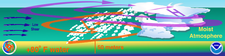
Subject A12) How do tropical cyclones form ?
Contributed by Chris Landsea.
To undergo tropical cyclogenesis, there are several favorable precursor environmental conditions that must be in place (Gray 1968, 1979):
- Warm ocean waters (of at least 26.5°C [80°F]) throughout a sufficient depth (unknown how deep, but at least on the order of 50 m [150 ft]). Warm waters are necessary to fuel the heat engine of the tropical cyclone.
- An atmosphere which cools fast enough with height such that it is potentially unstable to moist convection. It is the thunderstorm activity which allows the heat stored in the ocean waters to be liberated for the tropical cyclone development.
- Relatively moist layers near the mid-troposphere (5 km [3 mi]). Dry mid levels are not conducive for allowing the continuing development of widespread thunderstorm activity.
- A minimum distance of at least 500 km [300 mi] from the equator. For tropical cyclogenesis to occur, there is a requirement for non-negligible amounts of the Coriolis force to provide for near gradient wind balance to occur. Without the Coriolis force, the low pressure of the disturbance cannot be maintained.
- A pre-existing near-surface disturbance with sufficient vorticity and convergence. Tropical cyclones cannot be generated spontaneously. To develop, they require a weakly organized system with sizable spin and low level inflow.
- Low values (less than about 10 m/s [20 kts 23 mph]) of vertical wind shear between the surface and the upper troposphere. Vertical wind shear is the magnitude of wind change with height. Large values of vertical wind shear disrupt the incipient tropical cyclone and can prevent genesis, or, if a tropical cyclone has already formed, large vertical shear can weaken or destroy the tropical cyclone by interfering with the organization of deep convection around the cyclone center.
Having these conditions met is necessary, but not sufficient as many disturbances that appear to have favorable conditions do not develop. Recent work (Velasco and Fritsch 1987, Chen and Frank 1993, Emanuel 1993) has identified that large thunderstorm systems (called mesoscale convective complexes [MCC]) often produce an inertially stable, warm core vortex in the trailing altostratus decks of the MCC. These mesovortices have a horizontal scale of approximately 100 to 200 km [75 to 150 mi], are strongest in the mid-troposphere (5 km [3 mi]) and have no appreciable signature at the surface.
Zehr (1992) hypothesizes that genesis of the tropical cyclones occurs in two stages:
- stage 1 occurs when the MCC produces a mesoscale vortex.
- stage 2 occurs when a second blow up of convection at the mesoscale vortex initiates the intensification process of lowering central pressure and increasing swirling winds.
Subject A12) Why do tropical cyclones require at least 26.5°C ocean temperatures to form ?
Contributed by Chris Landsea.
Tropical systems can be thought of as engines that require warm, moist air as fuel (Emanuel, 1987).
This warm, moist air cools as it rises in convective clouds (thunderstorms) in the rainbands and eyewall of the tropical cyclone. The water vapor in the cloud condenses into water droplets releasing the latent heat which originally evaporated the water.
This latent heat provides the energy to drive the tropical cyclone circulation, though actually very little of the heat released is utilized by the storm to lower its surface pressure and increase the wind speeds.
In 1948 Erik Palmen observed that tropical cyclones required ocean temperatures of at least 26.5°C for their formation and growth.
Later work (e.g., Gray, 1979) also pointed out the need for this warm water to be present through a relatively deep layer (50 m) of the ocean. This 26.5°C value is tied to the instability of the atmosphere in the tropical and subtropical latitudes.
Above this temperature deep convection can occur, but below this value the atmosphere is too stable and little to no thunderstorm activity can be found (Graham and Barnett 1987).