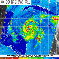
D1) Why do tropical cyclones' winds rotate counter-clockwise (clockwise) in the Northern (Southern) Hemisphere?
D2) What does "maximum sustained wind" mean ?
How does it relate to gusts in tropical cyclones ?
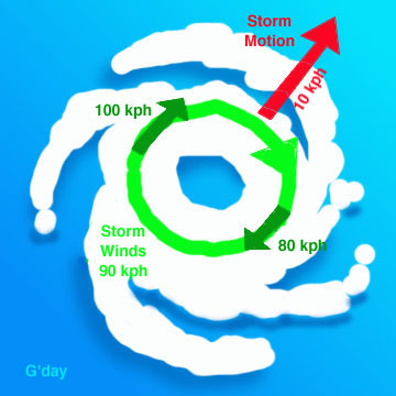
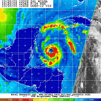
D3) Why are the strongest winds in a hurricane typically on the right side of the storm?
D4) How much energy does a hurricane release?
D5) What are "concentric eyewall cycles" (or
"eyewall replacement cycles") and why do they cause a hurricane's
maximum winds to weaken ?
D6) What causes each hurricane to have a different
maximum wind speed for that given minimum sea-level pressure?
D7) Why do hurricane force winds start at 64 knots ?
The reason is that the earth's rotation sets up an apparent force (called the Coriolis force) that pulls the winds to the right in the Northern Hemisphere (and to the left in the Southern Hemisphere). So when a low pressure starts to form north of the equator, the surface winds will flow inward trying to fill in the low and will be deflected to the right and a counter-clockwise rotation will be initiated. The opposite (a deflection to the left and a clockwise rotation) will occur south of the equator.
NOTE: This force is too tiny to effect rotation in, for example, water that is going down the drains of sinks and toilets. The rotation in those will be determined by the geometry of the container and the original motion of the water. Thus one can find both clockwise and counter- clockwise flowing drains no matter what hemisphere you are located. If you don't believe this, test it out for yourself.
Contributed by Chris Landsea
The OAR uses a 1-min averaging time for reporting the sustained (i.e. relatively long-lasting) winds. The maximum sustained wind mentioned in the advisories that NHC issues for tropical storms and hurricanes are the highest 1-min surface winds occurring within the circulation of the system. These "surface" winds are those observed (or, more often, estimated) to occur at the standard meteorological height of 10 m (33 ft) in an unobstructed exposure (i.e., not blocked by buildings or trees).
Since the inauguration of the Automatic Surface Observation System (ASOS) the National Weather Service has adopted a two minute average standard for its sustained wind definition. This is because the ASOS stations average and report their wind data over a two minute period. There is no conversion factor to change a two minute average wind into a one minute average wind, and it is pointless to try to estimate the highest one minute wind over a two minute period, as they are essentially the same.
Gusts are a few seconds (3-5 s) wind peak. Typically in a hurricane environment, the value of the maximum 3 second gust over a 1 minute period is on the order of 1.3 times (or 30% higher than) than the 1 min sustained wind.
One complication with the use of the 1 min averaging time for the standard for sustained wind in the Atlantic and Northeast Pacific tropical cyclone basins (where the United States has the official World Meteorological Organization tropical cyclone advisory responsibilities) is that in most of the rest of the world, a 10 min averaging time is utilized for "sustained wind". While one can utilize a simple ratio to convert from peak 10 min wind to peak 1 min wind (roughly 12% higher for the latter), such systematic differences to make interbasin comparison of tropical cyclones around the world problematic.
Powell, M.D., S.H. Houston, and T.A. Reinhold, 1996:"Hurricane Andrew's Landfall in South Florida, Part I: Standardizing measurements for documentation of surface wind fields." Wea. Forecast. v.11, p.329-349
Contributed by Chris Landsea
First, the "right side of the system" is defined with respect to the system's motion: if the cyclone is moving to the west, the left side would be to the south of the system; if the cyclone is moving to the north, the left side would be to the west of the system, etc...
Contributed by Chris Landsea
Hurricanes can be thought of, to a first approximation, as a heat engine; obtaining its heat input from the warm, humid air over the tropical ocean, and releasing this heat through the condensation of water vapor into water droplets in deep thunderstorms of the eyewall and rainbands, then giving off a cold exhaust in the upper levels of the troposphere (~12 km/8 mi up).
One can look at the energetics of a hurricane in two ways:
An average hurricane produces 1.5 cm/day (0.6 inches/day) of rain inside a circle of radius 665 km (360 n.mi) (Gray 1981). (More rain falls in the inner portion of hurricane around the eyewall, less in the outer rainbands.) Converting this to a volume of rain gives 2.1 x 1016 cm3/day. A cubic cm of rain weighs 1 gm. Using the latent heat of condensation, this amount of rain produced gives
For a mature hurricane, the amount of kinetic energy generated is
equal to that being dissipated due to friction. The dissipation
rate per unit area is air density times the drag coefficient
times the windspeed cubed (See Emanuel 1999 for details). One
could either integrate a typical wind profile over a range of
radii from the hurricane's center to the outer radius
encompassing the storm, or assume an average windspeed for the
inner core of the hurricane. Doing the latter and using 40 m/s
(90 mph) winds on a scale of radius 60 km (40 n.mi.), one gets a
wind dissipation rate (wind generation rate) of
Either method is an enormous amount energy being generated by
hurricanes. However, one can see that the amount of energy released
in a hurricane (by creating clouds/rain) that actually goes to
maintaining the hurricane's spiraling winds is a huge ratio of
400 to 1.
Contributed by Stan Goldenberg
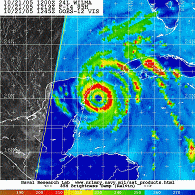


"Concentric eyewall cycles" (or "eyewall replacement cycle" ) naturally occur in intense tropical cyclones , i.e. major hurricanes (winds > 50 m/s, 100 kt, 115 mph) or Categories 3, 4, and 5 on the Saffir-Simpson scale. As tropical cyclones reach this threshold of intensity, they usually - but not always - have an eyewall and radius of maximum winds that contract to a very small size, around 10 to 25 km [5 to 15 mi]. At this point, some of the outer rainbands may organize into an outer ring of thunderstorms that slowly moves inward and robs the inner eyewall of its needed moisture and momentum. During this phase, the tropical cyclone is weakening (i.e. the maximum winds die off a bit and the central pressure goes up). Eventually the outer eyewall replaces the inner one completely and the storm can be the same intensity as it was previously or, in some cases, even stronger. A concentric eyewall cycle occurred in Hurricane Andrew (1992) before landfall near Miami: a strong intensity was reached, an outer eyewall formed, this contracted in concert with a pronounced weakening of the storm, and as the outer eyewall completely replaced the original one the hurricane reintensified. Another example is Hurricane Allen (1980) which went through repeated eyewall replacement cycles -- going from Category 5 to Category 3 status several times. To learn more about concentric eyewall cycles, read Willoughby et al. (1982) and Willoughby (1990a).
It was the discovery of concentric eyewall cycles that was
partially responsible for the end of the U.S. Governments's
hurricane modification experiment Project STORMFURY, since what the scientists had hoped to
produce through seeding was happening frequently as a natural part
of hurricane dynamics.
Contributed by Chris Landsea
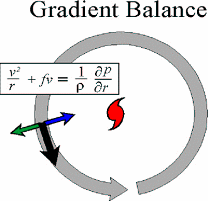
The basic horizontal balance in a tropical cyclone above the boundary layer is between the sum of the Coriolis 'acceleration' and the centripetal 'acceleration', balanced by the horizontal pressure gradient force. This balance is referred to as gradient balance, where the Coriolis 'acceleration' is defined as the horizontal velocity of an air parcel, v, times the Coriolis parameter, f.
Centripetal 'force' is defined as the acceleration on a parcel of air moving in a curved path, directed toward the center of curvature of the path, with magnitude v2/r, where v is the horizontal velocity of the parcel and r the radius of curvature of the path. The centripetal force alters the original two-force geostrophic balance and creates a non-geostrophic gradient wind.
The reason that different peak winds can result in different central pressures is caused by the fact that the radius, r, of the peak wind varies. A storm with 40 m/s peak winds with a 100 km RMW will have a much lower pressure drop than one with a 25 km RMW.
Contributed by Neal Dorst
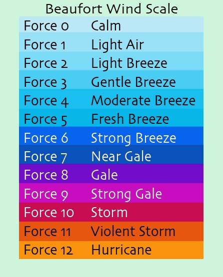 In 1805-06, Commander Francis Beaufort RN (later Admiral Sir Francis Beaufort) devised a descriptive wind scale in an effort to standardize wind reports in ship's logs. His scale divided wind speeds into 14 Forces (soon after pared down to thirteen) with each Force assigned a number, a common name, and a description of the effects such a wind would have on a sailing ship. And since the worst storm an Atlantic sailor was likely to run into was a hurricane, that name was applied to the top Force on the scale.