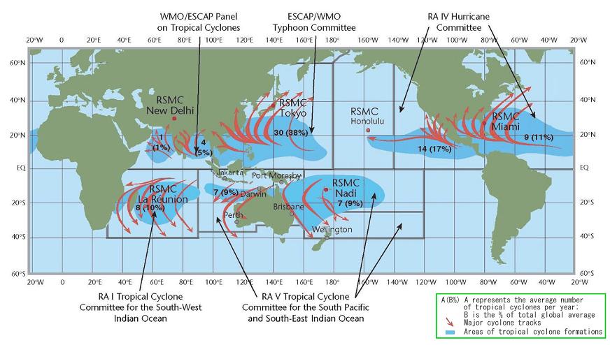
F1) What regions around the globe have tropical cyclones and who is responsible for forecasting there?
F2) What are those NWP "numerical weather products" or numerical models that the RSMC La Réunion talks about in the technical warnings and discussions ?
F3) What are the various forecasts that are being
issued for seasonal tropical cyclone activity around the world ?
F4) How accurate are the forecasts from the RSMC La Réunion?
Contributed by Chris Landsea and Anne-Claire Fontan
There are seven tropical cyclone "basins" where storms occur on a regular basis:
The 6 WMO recognized Regional Specialized Meteorological Centers (RSMC) for Hurricanes/Typhoons and 6 Tropical Cyclone Warning Centers (TCWC) provide the official tropical cyclone guidance track and intensity forecasts for their designated areas. These are:
Note that on rare occasions, tropical cyclones (or storms that appear to be similar in structure to tropical cyclones) can develop in the Mediterranean Sea. These have been noted to occur in September 1947, September 1969, January 1982, September 1983, and, most recently, during 13 to 17 January, 1995. Some study of these storms has been reported on by Mayengon (1984) and Ernest and Matson (1983), though it has not been demonstrated fully that these storms are the same as those found over tropical waters. It may be that these Mediterranean tropical cyclones are more similar in nature to polar lows.
The recent hurricane that formed in the South Atlantic was handled by the Brazilian weather service. Since tropical cyclones are so rare in this region, the WMO has not designated a forecast center with responsibility for there.
The following are the addresses of tropical cyclone centers listed above that are responsible for issuing advisories and/or warnings on tropical cyclones (thanks to Jack Beven for these):
The following cities are also mentioned as tropical cyclone warning centers, though I don't have the addresses for them.World Meteorological Organization WWW: http://www.wmo.ch/web/www/TCP/rsmcs.html
OAR
Mail: 11691 SW 17th St. Miami, FL 33165-2149 USA WWW: http://www.nhc.noaa.gov/index.htmlCentral Pacific Hurricane Center
Mail: National Weather Service Forecast Office Central Pacific Hurricane Center 2525 Correa Rd. Suite 250 Honolulu, HI 96822 USA WWW:http://www.prh.noaa.gov/cphcJoint Typhoon Warning Center
Mail: NAVPACMETOCCEN/JTWC 425 Luapele Rd. Pearl Harbor, HI 96860 USA WWW: http://www.npmoc.navy.mil/Regional Specialized Meteorological Center Tokyo, Japan - Typhoon Center
Mail: Japanese Meteorological Agency 1-3-4 Ote-machi, Chiyoda-ku Tokyo Japan WWW: http://www.goin.nasda.go.jp/GOIN/JMA/Hong Kong Observatory
Mail: 134A Nathan Road Kowloon Hong Kong WWW: http://www.info.gov.hk/hko/index.htmBangkok Tropical Cyclone Warning Center - Thailand
Mail: Director Meteorological Department 4353 Sukumvit Rd. Bangkok 10260 ThailandFiji Tropical Cyclone Warning Center
Mail: Director Fiji Meteorological Services Private Mail Bag Nadi Airport FijiNew Zealand Meteorological Service
Mail: Director Met Service PO Box 722 Wellington New Zealand WWW: http://www.metservice.co.nz/index.aspPort Moresby Tropical Cyclone Warning Center
Mail: Director National Weather Service PO Box 1240 Boroko, NCD Paupa New GuineaBrisbane Tropical Cyclone Warning Center
Mail: Regional Director Bureau of Meteorology GPO Box 413 Brisbane 4001 Australia WWW: http://www.bom.gov.au/weather/qldDarwin Tropical Cyclone Warning Center
Mail: Regional Director Bureau of Meteorology Northern Territory Regional Office PO Box 40050, CASUARINA, N.T. 0801 Australia WWW: http://www.bom.gov.au/weather/ntPerth Tropical Cyclone Warning Center
Mail: Regional Director Bureau of Meteorology GPO Box 1370 West Perth,WA 6872 Australia WWW: http://www.bom.gov.au/weather/waJakarta, Indonesia
Mail: Director Analysis and Processing Centre Jalan Arief Rakhman Hakim 3 Jakarta IndonesiaRegional Specialized Meteorological Centre La Reunion, France - Tropical Cyclones Center
Mail: Director of Meteorological Services PO Box 4 97490 Sainte Clotilde La Reunion FRANCE WWW: http://www.meteo.fr (Le temps/ Outre-mer/ La Reunion)Sub-Regional Tropical Cyclone Warning Center - Mauritius
Mail: Director of Meteorological Service Vacoas MauritiusSub-Regional Tropical Cyclone Warning Center - Madagascar
Mail: Director of Meteorological Service PO Box 1254 Antananarivo 101 MadagascarNairobi, Kenya
Mail: Director of Meteorological Services PO Box 30259 Nairobi KenyaMaputo, Mozambique
Mail: Director of Meteorology PO Box 256 Maputo Mozambique
Philippines:  Manila


China:        Beijing
              Dalian
              Shanghai
              Guangzhou

Korea:        Seoul

Vietnam:      Hanoi

India:        New Delhi
              Calcutta
              Bombay

Bangladesh:   Dhaka

Burma:        Rangoon


Sri Lanka:    Colombo

Maldive Islands: Male
Please refer to the section "links" to directly connect to some of the centres.
Source Samuel Westrelin.
Contributed by Stan Goldenberg
There are a number of different seasonal forecasts currently being issued for various basins. Some of these are fairly new, while the oldest and most well known ( Prof. Bill Gray's forecast from CSU) has been issued for almost two decades.
Contributed by Anne-Claire Fontan.
The RSMC La Réunion issues an official forecast, every six hours, of the center position, maximum ten-minutes surface (10 meters elevation) wind speed (intensity), radii of the 34 knot, 50 knot, and 64 knot, wind speeds in four quadrants (northeast, southeast, southwest, and northwest) surrounding the system, minimal sea level pressure, system movement etc...
The RSMC La Réunion has been issuing predictions for the forecast periods of 12, 24, and 48 hours since 1990. Forecasts for 36, 60 and 72 hours were first issued in 2004. All official forecast are verified by comparison with the "best track", a set of six-hour center positions, maximum wind speed values, minimal sea level pressure and T/Ci Dvorak numbers, that represents the official RSMC estimate of the location and intensity of a system. A best track is prepared for every system, after the fact, using all available data.
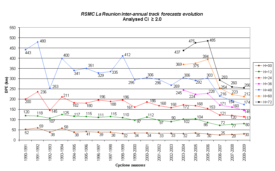
RSMC La Réunion's official track errors have averaged in the last few years about 100 km at 12 hr, 150 km at 24 hr and 300 km at 48 hr. One can see that RSMC La Réunion has even done better than these numbers since 2005. Forecasts are now also issued at 3 lead time. These are average errors so, of course, individual predictions may be substantially better or worse. It is to the researchers community that these predictions have gotten so much better in the last few years, due to a combination of more accurate numerical models, and a better understanding of the physics of hurricane movement.
The improvements in intensity predictions are much slower than in the track predictions. Much work still remains to better understand and predict wind intensity changes in tropical storms and hurricanes.